
Thank you for supporting this site ❤️
Make a donation
Make a donation
Campitello di Fassa topographic map
Click on the map to display elevation.
Thank you for supporting this site ❤️
Make a donation
Make a donation
About this map
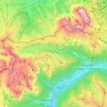
Name: Campitello di Fassa topographic map, elevation, terrain.
Average elevation: 2,070 m
Minimum elevation: 1,328 m
Maximum elevation: 3,179 m
Thank you for supporting this site ❤️
Make a donation
Make a donation
Other topographic maps
Click on a map to view its topography, its elevation and its terrain.
Primiero San Martino di Castrozza
Италия > Трентино - Альто-Адидже > Тренто
Average elevation: 1,946 m
Thank you for supporting this site ❤️
Make a donation
Make a donation
Maso Tòfoi
Италия > Трентино - Альто-Адидже > Тренто > Migazzone > Maso Tòfoi
Average elevation: 699 m
Jouf de Pordoi - Passo Pordoi - Pordoijoch
Италия > Трентино - Альто-Адидже > Тренто > Canazei
Average elevation: 2,283 m
Thank you for supporting this site ❤️
Make a donation
Make a donation