
Make a donation
Unnao topographic map
Click on the map to display elevation.
Make a donation
Unnao
Unnao lies in the great plains of the Ganges and hence the land is highly fertile. The soil is mostly alluvial. The Ganges separates Unnao from Kanpur district. The district is bounded by river Ganges in the west and the river Sai in the east. The entire district falling in Sai Sub-basin of the Ganges basin represents flat topography. The irrigation in the district takes place through Sharda Canal network system and tubewells. About 92% of the district area is under cultivation. The district has a subtropical climate. The district is mainly drained by the river Ganges and its tributaries Kalyani, Khar, Loni and Marahai in the western part of the district, and by Sai river in the eastern part of the district. All these rivers are perennial in nature. About 87% area of the net sown area (3,00,000 hectares) is irrigated both by surface water (Sharda Canal network system) and ground water through shallow and moderately deep tubewells. The share of surface water irrigation is 48% while that of ground water is 52%. The economy of the district mainly depends on agriculture.
Make a donation
About this map
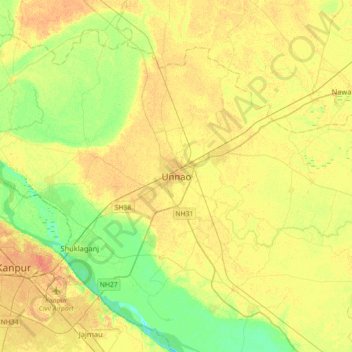
Name: Unnao topographic map, elevation, terrain.
Location: Unnao, Uttar Pradesh, 209800, India (26.38358 80.32715 26.70358 80.64715)
Average elevation: 123 m
Minimum elevation: 105 m
Maximum elevation: 137 m
Make a donation