
Make a donation
Mount Wellington topographic map
Click on the map to display elevation.
Make a donation
Mount Wellington
"... In many parts the Eucalypti grew to a great size, and composed a noble forest. In some of the dampest ravines, tree-ferns flourished in an extraordinary manner; I saw one which must have been at least twenty feet high to the base of the fronds, and was in girth exactly six feet. The fronds forming the most elegant parasols, produced a gloomy shade, like that of the first hour of the night. The summit of the mountain is broad and flat, and is composed of huge angular masses of naked greenstone. Its elevation is 3,100 feet [940 m] above the level of the sea. The day was splendidly clear, and we enjoyed a most extensive view; to the north, the country appeared a mass of wooded mountains, of about the same height with that on which we were standing, and with an equally tame outline: to the south the broken land and water, forming many intricate bays, was mapped with clearness before us. ..."
Make a donation
About this map
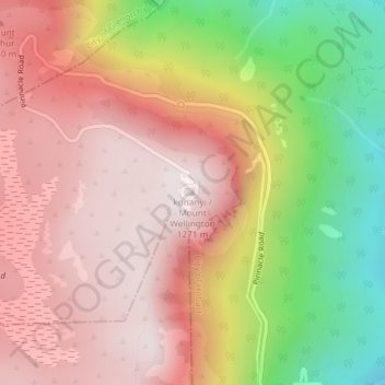
Name: Mount Wellington topographic map, elevation, terrain.
Location: Mount Wellington, City of Hobart, Tasmania, Australia (-42.89606 147.23726 -42.89596 147.23736)
Average elevation: 941 m
Minimum elevation: 443 m
Maximum elevation: 1,263 m
Make a donation
Other topographic maps
Click on a map to view its topography, its elevation and its terrain.
Make a donation
Launceston
Launceston is at 41°26′31″S 147°8′42″E / 41.44194°S 147.14500°E / -41.44194; 147.14500 in the Tamar Valley, Northern Tasmania. The valley was formed by volcanic and glacial forces over 10 million years ago. The city is about 45 kilometres (28 mi) south of the Bass Strait, with its closest…
Average elevation: 194 m
Make a donation
Make a donation
Hobart
Although Hobart itself rarely receives snow during the winter due to the foehn effect created by the Central Highlands (the city's geographic position causes a rainshadow), the adjacent Kunanyi/Mount Wellington is frequently seen with a snowcap throughout the year including in summer. During the 20th century,…
Average elevation: 179 m