
Make a donation
Small Waterfall topographic map
Click on the map to display elevation.
Make a donation
About this map
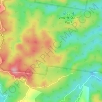
Name: Small Waterfall topographic map, elevation, terrain.
Average elevation: 389 m
Minimum elevation: 315 m
Maximum elevation: 483 m
Make a donation
Other topographic maps
Click on a map to view its topography, its elevation and its terrain.
Make a donation
Fitzroy
Australia > Victoria > Melbourne
Fitzroy's topography is flat. It is laid out in grid plan and is characterised by a fairly tightly spaced rectangular grid of medium-sized streets, with many of its narrow streets and back lanes facilitating only one-way traffic. Its built form is a legacy of its early history when a mixture of land uses was…
Average elevation: 35 m
Make a donation
Make a donation
Make a donation
Make a donation
Mount Buller
Due to its far south-western location in the alpine region, Mount Buller is more susceptible to cold airmasses which allow it to record some of the lowest maximum temperatures and daytime readings in the country, despite being considerably lower in elevation than other mountain sites to the north-east. On 05…
Average elevation: 824 m
Make a donation
Make a donation
Make a donation
Make a donation
Make a donation
Mount Macedon
Due to its relatively high elevation of approximately 620 metres (2,030 ft) AHD, the area experiences much cooler temperatures on average relative to nearby Melbourne. The area also receives high rainfall relative to the surrounding plains and much of the Melbourne area. This combination of geographic factors…
Average elevation: 673 m
Make a donation
Make a donation
City of Melbourne
Melbourne's topography is characterized by a diverse landscape that transitions from flat coastal plains to rolling hills and mountainous regions. The city is situated at the northern end of Port Phillip Bay, where the terrain is predominantly flat, facilitating urban development. As one moves eastward, the…
Average elevation: 20 m
Make a donation
Make a donation
Make a donation
Make a donation
Make a donation
Make a donation
Make a donation
Bairnsdale
A comprehensive geological survey of Victoria's Great Dividing Range reveals a distinct north-south alignment in its bedrock, a vestige of the bygone epochs of plate tectonics. This enduring geological framework, coupled with ongoing tectonic activity, contributes to the dynamic topography witnessed in the…
Average elevation: 25 m
Make a donation
Make a donation
Oakleigh South
Australia > Victoria > Melbourne
A 2005 report called Liveable Melbourne that was commissioned by The Age and conducted by Tract Consultants and ACIL Tasman, ranked Melbourne suburbs and assigned them scores on fourteen characteristics such as crime, CBD proximity, and traffic congestion. The report found that Oakleigh South had a very low…
Average elevation: 55 m
Make a donation
Make a donation
Make a donation
Make a donation