
Make a donation
Rappottenstein topographic map
Click on the map to display elevation.
Make a donation
Rappottenstein
Die Gemeinde besteht aus den Katastralgemeinden Dietharts, Gretschen, Großgundholz, Grünbach, Hausbach, Höhendorf, Kirchbach, Kleinnondorf, Lembach, Neustift, Oberrabenthan, Pehendorf, Pfaffendorf, Rappottenstein, Reichenbach, Riebeis, Ritterkamp, Roiten und Selbitz.
Make a donation
About this map
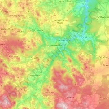
Name: Rappottenstein topographic map, elevation, terrain.
Average elevation: 732 m
Minimum elevation: 549 m
Maximum elevation: 927 m
Make a donation
Other topographic maps
Click on a map to view its topography, its elevation and its terrain.
Glashütte
Österreich > Niederösterreich > Bezirk Zwettl > Gemeinde Gutenbrunn > Gutenbrunn
Average elevation: 896 m
Make a donation
Blessberg
Österreich > Niederösterreich > Bezirk Zwettl > Gemeinde Grafenschlag
Average elevation: 752 m
Gerlas
Österreich > Niederösterreich > Bezirk Zwettl > Gemeinde Zwettl-Niederösterreich
Average elevation: 600 m
Rudmanns
Österreich > Niederösterreich > Bezirk Zwettl > Gemeinde Zwettl-Niederösterreich
Average elevation: 576 m
Waldsaß
Österreich > Niederösterreich > Bezirk Zwettl > Gemeinde Zwettl-Niederösterreich
Average elevation: 678 m
Make a donation
Schweiggers
Österreich > Niederösterreich > Bezirk Zwettl > Gemeinde Schweiggers
Average elevation: 640 m
Make a donation
Groß Gerungs
Österreich > Niederösterreich > Bezirk Zwettl > Gemeinde Groß Gerungs > Groß Gerungs
Average elevation: 734 m
Bruderndorf
Österreich > Niederösterreich > Bezirk Zwettl > Langschlag > Bruderndorf
Average elevation: 793 m
Bogenberg
Österreich > Niederösterreich > Bezirk Zwettl > Gemeinde Waldhausen
Average elevation: 669 m
Make a donation
Bad Traunstein
Österreich > Niederösterreich > Bezirk Zwettl > Gemeinde Bad Traunstein
Average elevation: 863 m
Kleinotten
Österreich > Niederösterreich > Bezirk Zwettl > Gemeinde Zwettl-Niederösterreich
Average elevation: 593 m