
Make a donation
Looc topographic map
Click on the map to display elevation.
Make a donation
Looc
Looc is located along the shores of Looc Bay on the southern portion of Tablas Island. It is bordered to the north by the municipalities of Ferrol and Odiongan, to east by the municipality of Alcantara, to the south by the municipality of Santa Fe and to the west by Looc Bay and Tablas Strait. It has a total land area of 13,282 hectares (32,820 acres). Its topography consists predominantly of slopes which are characterized as nearly level to slightly and strongly undulated rolling hills.
Make a donation
About this map
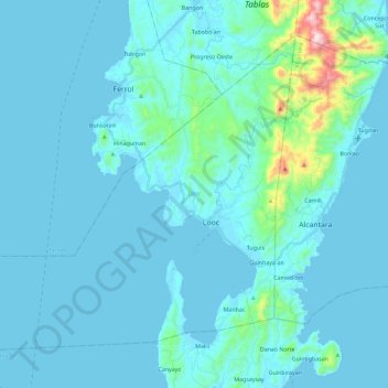
Name: Looc topographic map, elevation, terrain.
Location: Looc, Romblon, Mimaropa, 5507, Philippines (12.18288 121.82104 12.36888 122.04163)
Average elevation: 51 m
Minimum elevation: 0 m
Maximum elevation: 601 m
Make a donation
Other topographic maps
Click on a map to view its topography, its elevation and its terrain.
Make a donation
Make a donation
Make a donation
Make a donation
Make a donation
Mount Guiting-Guiting
Philippines > Romblon > Cajidiocan
Mount Guiting-Guiting or G2 is the highest mountain in the province of Romblon, located in Sibuyan Island, in the Philippines, with an elevation of 6,752 ft (2,058 m) above sea level. Its steep slopes and jagged peak, have earned it the reputation, as one of the most difficult and technically most challenging…
Average elevation: 1,478 m
Make a donation
roadside view of Mt.Guiting-Guiting
Philippines > Romblon > Magdiwang > Sitio Agnonoc
Average elevation: 10 m
Make a donation
Make a donation