
Thank you for supporting this site ❤️
Make a donation
Make a donation
Le Mont topographic map
Click on the map to display elevation.
Thank you for supporting this site ❤️
Make a donation
Make a donation
About this map
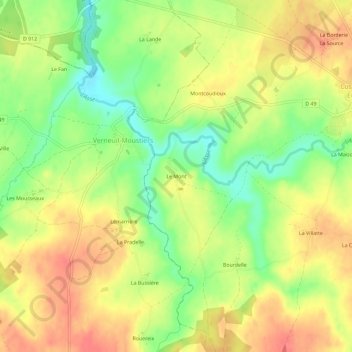
Name: Le Mont topographic map, elevation, terrain.
Average elevation: 200 m
Minimum elevation: 165 m
Maximum elevation: 229 m
Thank you for supporting this site ❤️
Make a donation
Make a donation
Other topographic maps
Click on a map to view its topography, its elevation and its terrain.
Lussac-les-Églises
Frankrijk > Nieuw-Aquitanië > Haute-Vienne > Lussac-les-Églises
Average elevation: 207 m