
Thank you for supporting this site ❤️
Make a donation
Make a donation
Augusta County topographic map
Click on the map to display elevation.
Thank you for supporting this site ❤️
Make a donation
Make a donation
About this map
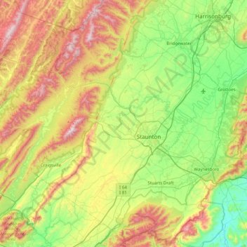
Name: Augusta County topographic map, elevation, terrain.
Location: Augusta County, Virginia, United States (37.88165 -79.53331 38.47768 -78.74939)
Average elevation: 569 m
Minimum elevation: 171 m
Maximum elevation: 1,342 m
Thank you for supporting this site ❤️
Make a donation
Make a donation
Other topographic maps
Click on a map to view its topography, its elevation and its terrain.