
Make a donation
Aberdeen City topographic map
Click on the map to display elevation.
Make a donation
Aberdeen City
Two weather stations collect climate data for the area, Aberdeen/Dyce Airport, and Craibstone. Both are about 4+1⁄2 miles (7 km) to the north west of the city centre, and given that they are in close proximity to each other, exhibit very similar climatic regimes. Dyce tends to have marginally warmer daytime temperatures year round owing to its slightly lower elevation, though it is more susceptible to harsh frosts. The coldest temperature to occur in recent years was −16.8 °C (1.8 °F) during December 2010, while the following winter, Dyce set a new February high temperature station record on 28 February 2012 of 17.2 °C (63.0 °F), and a new March high temperature record of 21.6 °C (70.9 °F) on 25 March 2012.
Make a donation
About this map
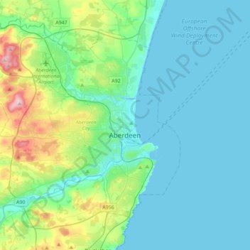
Name: Aberdeen City topographic map, elevation, terrain.
Location: Aberdeen City, Scotland, United Kingdom (57.07619 -2.36094 57.23531 -2.01615)
Average elevation: 46 m
Minimum elevation: 0 m
Maximum elevation: 262 m
Make a donation
Other topographic maps
Click on a map to view its topography, its elevation and its terrain.
Edinburgh
United Kingdom > Scotland > Edinburgh
Some have called Edinburgh the Athens of the North for a variety of reasons. The earliest comparison between the two cities showed that they had a similar topography, with the Castle Rock of Edinburgh performing a similar role to the Athenian Acropolis. Both of them had flatter, fertile agricultural land…
Average elevation: 104 m
Glasgow
United Kingdom > Scotland > Glasgow City
Glasgow itself was reputed to have been founded by the Christian missionary Saint Mungo in the 6th century. He established a church on the Molendinar Burn, where the present Glasgow Cathedral stands, and in the following years Glasgow became a religious centre. Glasgow grew over the following centuries. The…
Average elevation: 128 m
Aberlour
United Kingdom > Scotland > Moray
According to the 1846 A Topographical Dictionary of Scotland, "This parish, formerly called Skirdustan, signifying, in the Gaelic tongue, 'the division of Dustan', its tutelary saint, derived its present name from its situation at the mouth of a noisy burn, which discharges itself into the river Spey."
Average elevation: 160 m
Dundee
United Kingdom > Scotland > Dundee City
Dundee sits on the north bank of the Firth of Tay on the eastern, North Sea Coast of Scotland. The city lies 36.1 miles (58 km) NNE of Edinburgh and 360.6 miles (580 km) NNW of London. The built-up area occupies a roughly rectangular shape 8.3 miles (13 km) long by 2.5 miles (4 km) wide, aligned in an east to…
Average elevation: 82 m
Make a donation
Bathgate
United Kingdom > Scotland > West Lothian
In the 1846 book A Topographical Dictionary of Scotland, Samuel Lewis writes.
Average elevation: 167 m
Make a donation
Pentland Hills Regional Park
United Kingdom > Scotland > Edinburgh > Peggyslea
Average elevation: 249 m
Make a donation
Make a donation
Ormiston
United Kingdom > Scotland > East Lothian
Ormiston is a village in East Lothian, Scotland, near Tranent, Humbie, Pencaitland and Cranston, located on the north bank of the River Tyne at an elevation of about 276 feet (84 m).
Average elevation: 102 m
Make a donation
Make a donation
Ben Nevis
United Kingdom > Scotland > Highland
Ben Nevis has a highland (alpine) maritime (oceanic) polar climate (ET climate in the Köppen classification). Ben Nevis's elevation, maritime location and topography frequently lead to cool and cloudy weather conditions, which can pose a danger to ill-equipped walkers. According to the observations carried…
Average elevation: 912 m
Make a donation
Scottish Highlands
United Kingdom > Scotland > Highland
The entire region was covered by ice sheets during the Pleistocene ice ages, save perhaps for a few nunataks. The complex geomorphology includes incised valleys and lochs carved by the action of mountain streams and ice, and a topography of irregularly distributed mountains whose summits have similar heights…
Average elevation: 907 m
Make a donation
Ailsa Craig
In a small glen above Ailsa Castle, a small freshwater body known as the Garry Loch is located at an altitude of 247 m (810 ft), with a depth of at least 17 feet.
Average elevation: 14 m
Make a donation
Mull of Kintyre
Ailsa Craig and the County Antrim coast of Ulster and Rathlin Island are all clearly visible from the Mull. On clearer days it is also possible to make out Malin Head in Inishowen in County Donegal in the west of Ulster, and the Ayrshire coast on the other side of Ailsa Craig. Other islands in the Firth of…
Average elevation: 84 m
Make a donation
Make a donation
Make a donation
Make a donation
Make a donation
Make a donation
Make a donation
Aberdeen
United Kingdom > Scotland > Aberdeen
Two weather stations collect climate data for the area, Aberdeen/Dyce Airport, and Craibstone. Both are about 4 1⁄2 miles (7 km) to the north west of the city centre, and given that they are in close proximity to each other, exhibit very similar climatic regimes. Dyce tends to have marginally warmer daytime…
Average elevation: 52 m
Make a donation
Cairngorm Mountains
United Kingdom > Scotland > Aberdeenshire
In terms of height, remoteness and the severe and changeable weather, the Cairngorms are the most arduous area in the United Kingdom. The plateau area has a Tundra climate (Köppen ET), and the shattered terrain is more like the high ground in high-arctic Canada or northern Norway than what is often observed…
Average elevation: 937 m
Make a donation
Culloden Battlefield
United Kingdom > Scotland > Highland > Newlands of Culloden > Leanach
Since 2001, the site of the battle has undergone topographic, geophysical and metal detector surveys in addition to archaeological excavations. Interesting finds have been made in the areas on which the fiercest fighting occurred on the government left wing, particularly where Barrell's and Dejean's regiments…
Average elevation: 141 m
Make a donation
Ben More
United Kingdom > Scotland > Argyll and Bute
Ben More (Scottish Gaelic: Beinn Mhòr, meaning "great mountain") is the highest mountain and only Munro (mountains in Scotland that reach an elevation of at least 3,000 feet or 914.4 metres) on the Isle of Mull, Scotland. It is also the highest peak in the Scottish isles – and the only Munro – apart from…
Average elevation: 574 m
Make a donation
Brimmond Hill
United Kingdom > Scotland > Aberdeen City
Brimmond Hill is a hill in Aberdeen, Scotland. The summit is the highest point within the Aberdeen City council area, at an elevation of 266 m (873 ft).
Average elevation: 165 m
Make a donation
Make a donation
Falkirk
United Kingdom > Scotland > Falkirk
Falkirk is located in an area of undulating topography between the Slamannan Plateau and the upper reaches of the Firth of Forth. The area to the north of Falkirk is part of the floodplain of the River Carron. Two tributaries of the River Carron - the East Burn and the West Burn flow through the town and form…
Average elevation: 69 m
Make a donation
Make a donation
Ballater
United Kingdom > Scotland > Aberdeenshire
Ballater (/ˈbælətər/, Scottish Gaelic: Bealadair) is a village in Aberdeenshire, Scotland, on the River Dee, immediately east of the Cairngorm Mountains. Situated at an elevation of 213 metres (699 feet), Ballater is a centre for hikers and known for its spring water, once said to cure scrofula. It is home…
Average elevation: 360 m
Make a donation