
Thank you for supporting this site ❤️
Make a donation
Make a donation
Meschede topographic map
Click on the map to display elevation.
Thank you for supporting this site ❤️
Make a donation
Make a donation
About this map
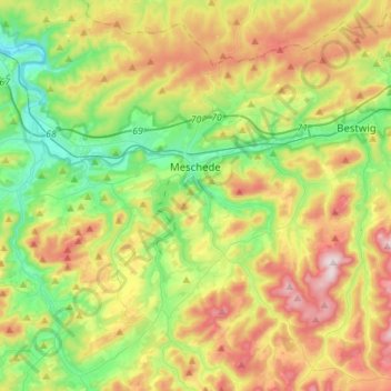
Name: Meschede topographic map, elevation, terrain.
Average elevation: 417 m
Minimum elevation: 209 m
Maximum elevation: 744 m
Thank you for supporting this site ❤️
Make a donation
Make a donation
Other topographic maps
Click on a map to view its topography, its elevation and its terrain.
Fleckenberg
Германия > Северный Рейн — Вестфалия > Hochsauerlandkreis > Schmallenberg
Average elevation: 458 m
Am Sterz
Германия > Северный Рейн — Вестфалия > Hochsauerlandkreis > Meschede
Average elevation: 374 m