
Thank you for supporting this site ❤️
Make a donation
Make a donation
Sungai Ular topographic map
Click on the map to display elevation.
Thank you for supporting this site ❤️
Make a donation
Make a donation
About this map
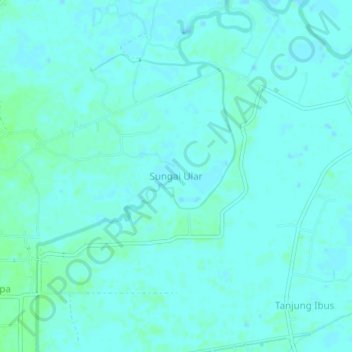
Name: Sungai Ular topographic map, elevation, terrain.
Location: Sungai Ular, Langkat, North Sumatra, Sumatra, Indonesia (3.87022 98.47277 3.91022 98.51277)
Average elevation: 3 m
Minimum elevation: -1 m
Maximum elevation: 8 m
Thank you for supporting this site ❤️
Make a donation
Make a donation