
Make a donation
Chumstick topographic map
Click on the map to display elevation.
Make a donation
About this map
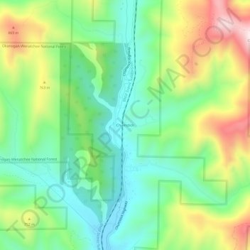
Name: Chumstick topographic map, elevation, terrain.
Location: Chumstick, Chelan County, Washington, 98826, United States (47.66818 -120.65926 47.70818 -120.61926)
Average elevation: 631 m
Minimum elevation: 437 m
Maximum elevation: 980 m
Make a donation
Other topographic maps
Click on a map to view its topography, its elevation and its terrain.
Wenatchee
United States > Washington > Chelan County
Wenatchee is characterized by its diverse topography, nestled at an average elevation of approximately 800 feet. The city is situated in a valley surrounded by significant geographical features, including the rugged foothills of the Cascade Mountains, which rise sharply to elevations of over 4,500 feet just to…
Average elevation: 302 m
Leavenworth
United States > Washington > Chelan County
Leavenworth, Washington, is nestled at approximately 1,171 feet (357 meters) above sea level in the eastern foothills of the Cascade Mountains. The town is surrounded by rugged terrain, with steep slopes that rise sharply to elevations exceeding 5,000 feet (1,524 meters), and prominent peaks such as Icicle…
Average elevation: 418 m
Make a donation
Saddle Rock Natural Area
United States > Washington > Chelan County > Wenatchee
Average elevation: 448 m
Make a donation
Make a donation
Make a donation
Entiat Slopes Natural Area Preserve
United States > Washington > Chelan County
Average elevation: 651 m
Leavenworth
United States > Washington > Chelan County
Leavenworth is situated in the Cascade Mountains at an elevation of 1,168 feet (356 m) above sea level and is surrounded by mountains that range from 5,000 to 8,000 feet (1,500 to 2,400 m) in height. The city lies along the Wenatchee River near its confluence with Icicle Creek. According to the United States…
Average elevation: 418 m
Entiat Slopes Natural Area Preserve
United States > Washington > Chelan County
Average elevation: 651 m
Make a donation
Make a donation
Make a donation