
Thank you for supporting this site ❤️
Make a donation
Make a donation
Great Bend topographic map
Click on the map to display elevation.
Thank you for supporting this site ❤️
Make a donation
Make a donation
Great Bend
Great Bend is located at 38°21′52″N 98°45′53″W / 38.36444°N 98.76472°W / 38.36444; -98.76472 (38.3644567, -98.7648073) at an elevation of 1,850 feet (564 m). Located in central Kansas at the intersection of U.S. Route 281 and U.S. Route 56, Great Bend is 95 miles (153 km) northwest of Wichita, 235 miles (378 km) west-southwest of Kansas City, and 345 miles (555 km) east-southeast of Denver.
Thank you for supporting this site ❤️
Make a donation
Make a donation
About this map
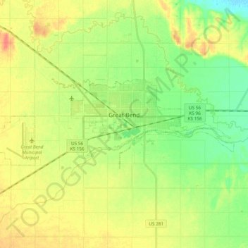
Name: Great Bend topographic map, elevation, terrain.
Location: Great Bend, Barton County, Kansas, 67530, United States (38.33027 -98.88497 38.38372 -98.69708)
Average elevation: 570 m
Minimum elevation: 549 m
Maximum elevation: 593 m
Thank you for supporting this site ❤️
Make a donation
Make a donation
Other topographic maps
Click on a map to view its topography, its elevation and its terrain.