
Make a donation
Mount Lamborn topographic map
Click on the map to display elevation.
Make a donation
About this map
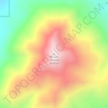
Name: Mount Lamborn topographic map, elevation, terrain.
Location: Mount Lamborn, Delta County, Colorado, United States (38.80300 -107.52288 38.80310 -107.52278)
Average elevation: 2,949 m
Minimum elevation: 2,427 m
Maximum elevation: 3,460 m
Make a donation
Other topographic maps
Click on a map to view its topography, its elevation and its terrain.
Cedaredge
United States > Colorado > Delta County
Located in a protected valley at 6,100 feet (1,900 m) in elevation, the Cedaredge Golf Club course has natural cedars and winding creek beds.
Average elevation: 1,883 m
Cedaredge
United States > Colorado > Delta County
Located in a protected valley at 6,100 feet (1,900 m) in elevation, the Cedaredge Golf Club course has natural cedars and winding creek beds.
Average elevation: 1,883 m
Cedaredge
United States > Colorado > Delta County
Located in a protected valley at 6,100 feet (1,900 m) in elevation, the Cedaredge Golf Club course has natural cedars and winding creek beds.
Average elevation: 1,883 m
Make a donation
Cedaredge
United States > Colorado > Delta County
Located in a protected valley at 6,100 feet (1,900 m) in elevation, the Cedaredge Golf Club course has natural cedars and winding creek beds.
Average elevation: 1,883 m
Make a donation