
Make a donation
Bhimad topographic map
Click on the map to display elevation.
Make a donation
Bhimad
Rangrung is famous for its altitude, accessing panoramic views of the broad Himalayan range. Hill Tower with telescope facilities will be constructed in the near future. This is popular for the resorts and overnight stayers. It has enormous potential for paragliding, this area is also famous for biodiversity. It is easily accessible through roads from major cities.
Make a donation
About this map
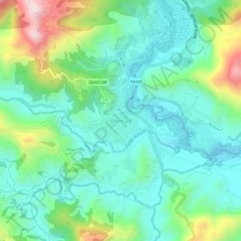
Name: Bhimad topographic map, elevation, terrain.
Location: Bhimad, Tanahun, Gandaki Province, Nepal (27.95830 84.05979 27.99830 84.09979)
Average elevation: 544 m
Minimum elevation: 399 m
Maximum elevation: 936 m
Make a donation
Other topographic maps
Click on a map to view its topography, its elevation and its terrain.
Bandipur
Nepal > Gandaki Province > Tanahun
Bandipur is located at 27.56 N, 84.25 E and an elevation of 1030m on a mountain saddle (Mahabharat range) approximately 700m above the Marsyangdi River Valley, 143 km to the west of Kathmandu and 80 km to the east of Pokhara. Since 1998 it is connected by an 8 km access road from Dumre (Prithvi Highway). Until…
Average elevation: 719 m
Make a donation
Bandipur
Nepal > Gandaki Province > Tanahun
Bandipur is located at 27.56 N, 84.25 E and an elevation of 1030m on a mountain saddle (Mahabharat range) approximately 700m above the Marsyangdi River Valley, 143 km to the west of Kathmandu and 80 km to the east of Pokhara. Since 1998 it is connected by an 8 km access road from Dumre (Prithvi Highway). Until…
Average elevation: 719 m