
Thank you for supporting this site ❤️
Make a donation
Make a donation
Cacuaco Municipality topographic map
Click on the map to display elevation.
Thank you for supporting this site ❤️
Make a donation
Make a donation
About this map
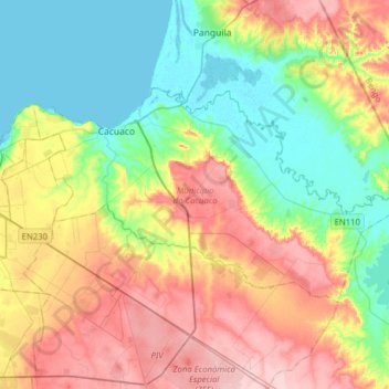
Name: Cacuaco Municipality topographic map, elevation, terrain.
Location: Cacuaco Municipality, Luanda Province, Angola (-8.91369 13.30297 -8.74278 13.61659)
Average elevation: 67 m
Minimum elevation: -3 m
Maximum elevation: 163 m
Thank you for supporting this site ❤️
Make a donation
Make a donation
Other topographic maps
Click on a map to view its topography, its elevation and its terrain.
Thank you for supporting this site ❤️
Make a donation
Make a donation
Thank you for supporting this site ❤️
Make a donation
Make a donation
Thank you for supporting this site ❤️
Make a donation
Make a donation
Thank you for supporting this site ❤️
Make a donation
Make a donation