
Make a donation
Sipitang topographic map
Click on the map to display elevation.
Make a donation
Sipitang
Sipitang district is located within a national and international route. Southern Sabah Federal Route 1 of the Pan Borneo Highway passes through this district, hence it can be reached from Beaufort from the north, Tenom from the east and Lawas, Sarawak from southwest. At the same time, the coastline stretches 16 kilometre off Brunei Bay and is an entry point for travellers from Brunei and Labuan. The district has a long coastline and has 4 main rivers flowing through it, that is the Lukutan river, Sipitang river, Mengalong river and Padas river. The Crocker Range can also be seen from this district as it crosses the district from south to southwest. The presence of small hills and flat lands near the coastal area is one of the main reasons for the frequent floods in Sipitang during the monsoon season. This topography has also influenced the temperature and rainfall distribution of the district. At lower lands less than 1,524 metres, the temperature is around 28 °C – 34 °C, while the rainfall distribution in the lowlands is much lower than the highlands.
Make a donation
About this map
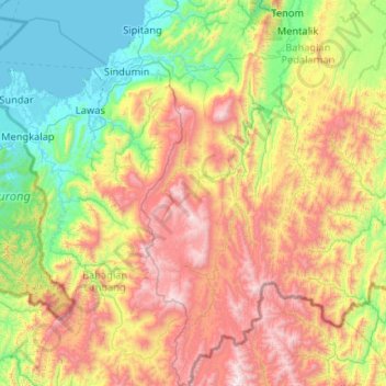
Name: Sipitang topographic map, elevation, terrain.
Location: Sipitang, Interior Division, Sabah, Malaysia (4.11489 115.44869 5.15392 115.87304)
Average elevation: 716 m
Minimum elevation: -2 m
Maximum elevation: 2,110 m
Make a donation
Other topographic maps
Click on a map to view its topography, its elevation and its terrain.
Mount Kinabalu
Mount Kinabalu (Malay: Gunung Kinabalu, Dusun: Gayo Ngaran or Nulu Nabalu) is the highest mountain in Borneo and Malaysia. With an elevation of 13,435 feet (4,095 m), it is third-highest peak of an island on Earth, and 20th most prominent mountain in the world by topographic prominence. The mountain is located…
Average elevation: 3,567 m
Make a donation
Make a donation
Make a donation
Make a donation
Make a donation
Make a donation
Make a donation
Make a donation
Mount Kinabalu
Low's Peak can be climbed by a person in good physical condition without mountaineering equipment on the main route. However, climbers must be accompanied by accredited guides at all times due to national park regulations and the risk of experiencing altitude sickness.
Average elevation: 3,567 m
Make a donation
Make a donation
Make a donation
Make a donation
Make a donation
Mount Kinabalu
Low's Peak can be climbed by a person in good physical condition without mountaineering equipment on the main route. However, climbers must be accompanied by accredited guides at all times due to national park regulations and the risk of experiencing altitude sickness.
Average elevation: 3,567 m
Make a donation
Make a donation
Make a donation
Make a donation
Make a donation
Make a donation
Make a donation
Make a donation
Make a donation
Make a donation
Make a donation