
Thank you for supporting this site ❤️
Make a donation
Make a donation
Mandirancan topographic map
Click on the map to display elevation.
Thank you for supporting this site ❤️
Make a donation
Make a donation
About this map
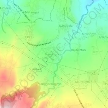
Name: Mandirancan topographic map, elevation, terrain.
Location: Mandirancan, Kuningan, West Java, Java, 45558, Indonesia (-6.83059 108.44988 -6.79059 108.48988)
Average elevation: 315 m
Minimum elevation: 182 m
Maximum elevation: 521 m
Thank you for supporting this site ❤️
Make a donation
Make a donation
Other topographic maps
Click on a map to view its topography, its elevation and its terrain.