
Thank you for supporting this site ❤️
Make a donation
Make a donation
Kandel topographic map
Click on the map to display elevation.
Thank you for supporting this site ❤️
Make a donation
Make a donation
Kandel
De Kandel is een 1241 meter hoge berg, 10,8 km ten oosten van de plaats Waldkirch in de Breisgau, in het Zwarte Woud, in het Duitse Bundesland Baden-Württemberg. Over de berg lopen drie geasfalteerde verkeerswegen naar de pashoogte op 1205 m boven zeeniveau.
Thank you for supporting this site ❤️
Make a donation
Make a donation
About this map
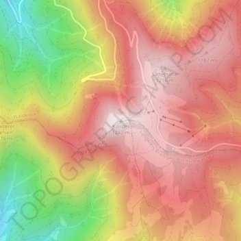
Name: Kandel topographic map, elevation, terrain.
Average elevation: 984 m
Minimum elevation: 568 m
Maximum elevation: 1,237 m
Thank you for supporting this site ❤️
Make a donation
Make a donation