
Make a donation
Udhagamandalam topographic map
Click on the map to display elevation.
Make a donation
Udhagamandalam
Ooty is located in the Nilgiri hills, which are part of the Western Ghats in the Nilgiri Biosphere Reserve. It is separated from the neighboring state of Karnataka by the Moyar river in the north and from the Anaimalai and Palani hills in the south by the Palghat Gap. It is situated at an altitude of 2,240 metres (7,350 feet) above sea level. The total area of the town is 30.36 km2 (11.72 sq mi). Doddabetta is the highest peak (2,623 m or 8,606 ft) in the Nilgiris, about 10 km (6.2 mi) from Ooty.
Make a donation
About this map
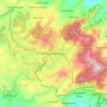
Name: Udhagamandalam topographic map, elevation, terrain.
Location: Udhagamandalam, Nilgiris, Tamil Nadu, 643001, India (11.37268 76.66305 11.45268 76.74305)
Average elevation: 2,234 m
Minimum elevation: 1,881 m
Maximum elevation: 2,622 m
Make a donation
Other topographic maps
Click on a map to view its topography, its elevation and its terrain.
Government Botanical Garden
India > Tamil Nadu > Udhagamandalam > Udhagamandalam
Average elevation: 2,325 m