
Make a donation
Garden Valley topographic map
Click on the map to display elevation.
Make a donation
About this map
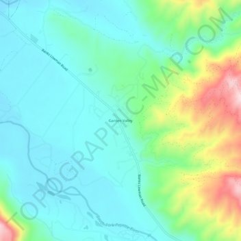
Name: Garden Valley topographic map, elevation, terrain.
Location: Garden Valley, Boise County, Idaho, 83622, United States (44.06989 -115.97206 44.10989 -115.93206)
Average elevation: 1,004 m
Minimum elevation: 920 m
Maximum elevation: 1,258 m
Make a donation
Other topographic maps
Click on a map to view its topography, its elevation and its terrain.
Idaho City
United States > Idaho > Boise County
Idaho City is located at 43°49′43″N 115°49′56″W / 43.82861°N 115.83222°W / 43.82861; -115.83222 (43.828513, -115.832175), at an elevation of 3,907 feet (1,191 m) above sea level.
Average elevation: 1,236 m
Horseshoe Bend
United States > Idaho > Boise County
The area was originally settled as a gold miners' staging area, as prospectors waited along the river for snows to thaw at the higher elevations. Gold had been discovered in 1862 in the Boise Basin mountains to the east, near Idaho City.
Average elevation: 867 m
Make a donation
Idaho City
United States > Idaho > Boise County
Idaho City is located at 43°49′43″N 115°49′56″W / 43.82861°N 115.83222°W / 43.82861; -115.83222 (43.828513, -115.832175), at an elevation of 3,907 feet (1,191 m) above sea level.
Average elevation: 1,236 m
Make a donation