
Make a donation
Dublin topographic map
Click on the map to display elevation.
Make a donation
About this map
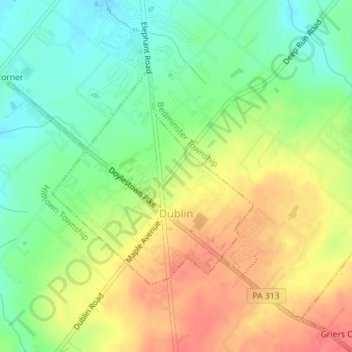
Name: Dublin topographic map, elevation, terrain.
Location: Dublin, Bucks County, Pennsylvania, 18917, United States (40.36610 -75.21410 40.38270 -75.19377)
Average elevation: 161 m
Minimum elevation: 132 m
Maximum elevation: 193 m
Make a donation
Other topographic maps
Click on a map to view its topography, its elevation and its terrain.
Village Shires
United States > Pennsylvania > Bucks County > Northampton Township
Average elevation: 57 m
Make a donation
Feasterville
United States > Pennsylvania > Bucks County > Lower Southampton Township
Average elevation: 66 m
Cornwells Heights
United States > Pennsylvania > Bucks County > Bensalem Township
Average elevation: 16 m
Castle Valley
United States > Pennsylvania > Bucks County > Doylestown Township
Average elevation: 84 m
Make a donation
Jericho Mountain
United States > Pennsylvania > Bucks County > Upper Makefield Township
Average elevation: 62 m
Warrington
United States > Pennsylvania > Bucks County > Warrington Township > Warrington
Average elevation: 87 m
Warminster
United States > Pennsylvania > Bucks County > Warminster Township > Warminster
Average elevation: 85 m
Make a donation
Point Pleasant
United States > Pennsylvania > Bucks County > Plumstead Township
Average elevation: 106 m
Southampton
United States > Pennsylvania > Bucks County > Upper Southampton Township
Average elevation: 75 m
Lake Nockamixon
United States > Pennsylvania > Bucks County > Haycock Township
Average elevation: 151 m
Make a donation
Smiths Corner
United States > Pennsylvania > Bucks County > Plumstead Township
Average elevation: 130 m
Make a donation
Mechanicsville
United States > Pennsylvania > Bucks County > Buckingham Township
Average elevation: 117 m
Make a donation
Warminster Heights
United States > Pennsylvania > Bucks County > Warminster Township
Average elevation: 86 m
Make a donation
Woodside
United States > Pennsylvania > Bucks County > Lower Makefield Township > Lower Makefield Township
Average elevation: 47 m
Make a donation
Applebachsville
United States > Pennsylvania > Bucks County > Haycock Township
Average elevation: 166 m
Make a donation
Blooming Glen
United States > Pennsylvania > Bucks County > Hilltown Township
Average elevation: 131 m
Make a donation
Make a donation
Forest Grove
United States > Pennsylvania > Bucks County > Buckingham Township
Average elevation: 83 m
Gallows Hill
United States > Pennsylvania > Bucks County > Springfield Township
Average elevation: 167 m
Make a donation
Make a donation
Holicong
United States > Pennsylvania > Bucks County > Buckingham Township > Buckingham
Average elevation: 96 m
Make a donation
Line Lexington
United States > Pennsylvania > Bucks County > New Britain Township
Average elevation: 108 m
Make a donation
Mount Pleasant
United States > Pennsylvania > Bucks County > Hilltown Township
Average elevation: 174 m
Penns Park
United States > Pennsylvania > Bucks County > Wrightstown Township > Wrightstown
Average elevation: 78 m
Make a donation
Pleasant Valley
United States > Pennsylvania > Bucks County > Springfield Township
Average elevation: 155 m
Make a donation
Upper Black Eddy
United States > Pennsylvania > Bucks County > Bridgeton Township
Average elevation: 100 m
Make a donation
Washington Crossing
United States > Pennsylvania > Bucks County > Upper Makefield Township
Average elevation: 36 m
Grenoble
United States > Pennsylvania > Bucks County > Northampton Township > Grenoble
Average elevation: 75 m
Make a donation
Plumsteadville
United States > Pennsylvania > Bucks County > Plumstead Township
Average elevation: 160 m
Lake Caroline Dam
United States > Pennsylvania > Bucks County > Falls Township > Fairless Hills
Average elevation: 32 m
Taylorsville
United States > Pennsylvania > Bucks County > Upper Makefield Township > Washington Crossing > Taylorsville
Average elevation: 37 m
Make a donation
Doylestown
United States > Pennsylvania > Bucks County > Doylestown
An electric telegraph station was built in 1846, and the North Pennsylvania Railroad completed a branch to Doylestown in 1856. The first gas lights were introduced in 1854. Because of the town's relatively high elevation and a lack of strong water power, substantial industrial development never occurred and…
Average elevation: 100 m
Fountainville
United States > Pennsylvania > Bucks County > New Britain Township
Average elevation: 120 m
Make a donation