
Thank you for supporting this site ❤️
Make a donation
Make a donation
Chartondu topographic map
Click on the map to display elevation.
Thank you for supporting this site ❤️
Make a donation
Make a donation
About this map
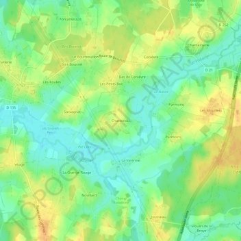
Name: Chartondu topographic map, elevation, terrain.
Average elevation: 198 m
Minimum elevation: 183 m
Maximum elevation: 214 m
Thank you for supporting this site ❤️
Make a donation
Make a donation
Other topographic maps
Click on a map to view its topography, its elevation and its terrain.
71580
France > Bourgogne-Franche-Comté > Saône-et-Loire > Sagy > Le Champ Moine
Average elevation: 223 m