
Thank you for supporting this site ❤️
Make a donation
Make a donation
Mount Olive topographic map
Click on the map to display elevation.
Thank you for supporting this site ❤️
Make a donation
Make a donation
About this map
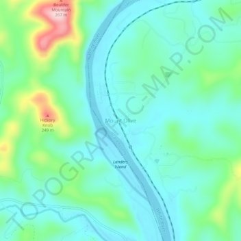
Name: Mount Olive topographic map, elevation, terrain.
Location: Mount Olive, Izard County, Arkansas, United States (35.98063 -92.11293 36.02063 -92.07293)
Average elevation: 146 m
Minimum elevation: 92 m
Maximum elevation: 327 m
Thank you for supporting this site ❤️
Make a donation
Make a donation
Other topographic maps
Click on a map to view its topography, its elevation and its terrain.