
Thank you for supporting this site ❤️
Make a donation
Make a donation
Galila / Simpson Farm topographic map
Click on the map to display elevation.
Thank you for supporting this site ❤️
Make a donation
Make a donation
About this map
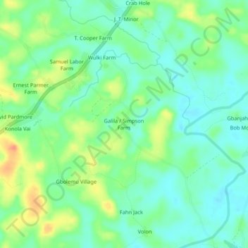
Name: Galila / Simpson Farm topographic map, elevation, terrain.
Location: Galila / Simpson Farm, Kakata, Margibi County, Liberia (6.60188 -10.26022 6.64188 -10.22022)
Average elevation: 95 m
Minimum elevation: 79 m
Maximum elevation: 124 m
Thank you for supporting this site ❤️
Make a donation
Make a donation