
Thank you for supporting this site ❤️
Make a donation
Make a donation
Scherr topographic map
Click on the map to display elevation.
Thank you for supporting this site ❤️
Make a donation
Make a donation
About this map
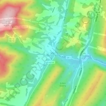
Name: Scherr topographic map, elevation, terrain.
Location: Scherr, Grant County, West Virginia, United States (39.17316 -79.19004 39.21316 -79.15004)
Average elevation: 589 m
Minimum elevation: 450 m
Maximum elevation: 829 m
Thank you for supporting this site ❤️
Make a donation
Make a donation
Other topographic maps
Click on a map to view its topography, its elevation and its terrain.