
Statesville topographic map
Interactive map
Click on the map to display elevation.
About this map
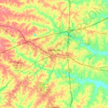
Name: Statesville topographic map, elevation, terrain.
Average elevation: 269 m
Minimum elevation: 220 m
Maximum elevation: 315 m
Statesville has a humid subtropical climate (Cfa) like most of the state of North Carolina, although its higher elevation leads to cooler temperatures than much of the Piedmont. Summers are generally hot and humid, with mild nights, while winters are usually cool with chilly nights and sporadic snowfall. Severe thunderstorms can be an issue during summer, with wind speeds of 60 mph and even gusts of 95 mph being recorded during these storms.
Other topographic maps
Click on a map to view its topography, its elevation and its terrain.
Mooresville
United States > North Carolina > Iredell County
Mooresville, Iredell County, North Carolina, 28115, United States
Average elevation: 252 m