
Make a donation
Milltown topographic map
Click on the map to display elevation.
Make a donation
About this map
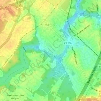
Name: Milltown topographic map, elevation, terrain.
Location: Milltown, Middlesex County, New Jersey, United States (40.43444 -74.44949 40.46337 -74.42310)
Average elevation: 22 m
Minimum elevation: 4 m
Maximum elevation: 40 m
Make a donation
Other topographic maps
Click on a map to view its topography, its elevation and its terrain.
Six Mile Run
United States > New Jersey > Middlesex County > North Brunswick > Adams
Average elevation: 34 m
Orchard Heights
United States > New Jersey > Middlesex County > East Brunswick Township
Average elevation: 32 m
Make a donation
Shore View
United States > New Jersey > Middlesex County > Woodbridge Township > Colonia
Average elevation: 29 m
Make a donation
Berdines Corners
United States > New Jersey > Middlesex County > North Brunswick
Average elevation: 29 m
South Brunswick Terrace
United States > New Jersey > Middlesex County > South Brunswick
Average elevation: 39 m
Make a donation
Woodbridge
United States > New Jersey > Middlesex County > Woodbridge Township
Average elevation: 16 m
New Market
United States > New Jersey > Middlesex County > Piscataway Township
Average elevation: 23 m
Make a donation
Make a donation
Bicentennial Park
United States > New Jersey > Middlesex County > East Brunswick Township > Farrington Lake Heights
Average elevation: 24 m
Highland Park
United States > New Jersey > Middlesex County > Highland Park > Highland Park
Average elevation: 24 m
Dunhams Corners
United States > New Jersey > Middlesex County > East Brunswick Township > Dunhams Corners
Average elevation: 33 m
Make a donation
Middlesex
United States > New Jersey > Middlesex County > Middlesex > Middlesex
Average elevation: 38 m
Farrington Lake Heights
United States > New Jersey > Middlesex County > East Brunswick Township > Farrington Lake Heights
Average elevation: 27 m
Make a donation
Lincoln Park
United States > New Jersey > Middlesex County > New Brunswick > Lincoln Park
Average elevation: 28 m
Make a donation