
Make a donation
Ampatuan topographic map
Click on the map to display elevation.
Make a donation
About this map
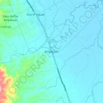
Name: Ampatuan topographic map, elevation, terrain.
Location: Ampatuan, Maguindanao del Sur, Bangsamoro, 9609, Philippines (6.79218 124.41710 6.87218 124.49710)
Average elevation: 49 m
Minimum elevation: 16 m
Maximum elevation: 345 m
Make a donation
Other topographic maps
Click on a map to view its topography, its elevation and its terrain.
Make a donation
Liguasan Marsh
Philippines > Maguindanao del Sur > General Salipada K. Pendatun
Average elevation: 9 m
Lake Buluan
Philippines > Maguindanao del Sur > Mangudadatu
Lake Buluan is a lake located in the island of Mindanao in the Philippines. With an estimated surface area of 61.34 square kilometres (23.68 sq mi), it is the third largest lake in Mindanao, after Lake Lanao and Lake Mainit. It has an average elevation of 4.5 metres (15 ft).
Average elevation: 48 m
Make a donation