
Make a donation
Mammoth Summit topographic map
Click on the map to display elevation.
Make a donation
About this map
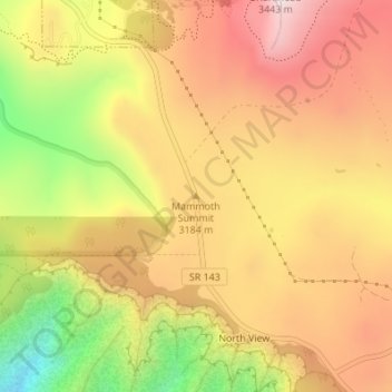
Name: Mammoth Summit topographic map, elevation, terrain.
Location: Mammoth Summit, Iron County, Utah, 84719, United States (37.66659 -112.83833 37.66669 -112.83823)
Average elevation: 3,150 m
Minimum elevation: 2,779 m
Maximum elevation: 3,417 m
Make a donation
Other topographic maps
Click on a map to view its topography, its elevation and its terrain.
Cedar City
United States > Utah > Iron County
Cedar City is located in the southeast Great Basin and is approximately 20 miles (32 km) north of the northeastern edge of the Mojave Desert. Its elevation of 5,846 feet (1,782 m) gives it a somewhat cooler climate compared to the nearby St. George region, though it retains cultural ties to the city —for…
Average elevation: 1,975 m
Brian Head
United States > Utah > Iron County
The community, at an elevation of 9,800 feet (3,000 m) above sea level, is the highest town in Utah. It is located on State Route 143 and is east of Interstate 15. Brian Head is approximately three miles north of Cedar Breaks National Monument.
Average elevation: 3,031 m
Cedar City
United States > Utah > Iron County
Cedar City is located in the southeast Great Basin and is approximately 20 miles (32 km) north of the northeastern edge of the Mojave Desert. Its elevation of 5,846 feet (1,782 m) gives it a somewhat cooler climate compared to the nearby St. George region, though it retains cultural ties to the city. For…
Average elevation: 1,975 m
Make a donation
Ashdown Gorge Wilderness
United States > Utah > Iron County
The wilderness is within the Dixie National Forest adjacent to Cedar Breaks National Monument and characterized by extremely steep-walled canyons cut through the west rim of the Markagunt Plateau. Elevations in the wilderness range from 10,500 feet (3,200 m) to 7,500 feet (2,300 m). Rattlesnake Creek and…
Average elevation: 2,715 m
Cedar City
United States > Utah > Iron County
Cedar City is located in the southeast Great Basin and is approximately 20 miles (32 km) north of the northeastern edge of the Mojave Desert. Its elevation of 5,846 feet (1,782 m) gives it a somewhat cooler climate compared to the nearby St. George region, though it retains cultural ties to the city —for…
Average elevation: 1,975 m
Make a donation
Cedar City
United States > Utah > Iron County
Cedar City is located in the southeast Great Basin and is approximately 20 miles (32 km) north of the northeastern edge of the Mojave Desert. Its elevation of 5,846 feet (1,782 m) gives it a somewhat cooler climate compared to the nearby St. George region, though it retains cultural ties to the city. For…
Average elevation: 1,975 m
Brian Head
United States > Utah > Iron County > Brian Head
The community, at an elevation of 9,800 feet (3,000 m) above sea level, is the highest town in Utah. It is located on State Route 143 and is east of Interstate 15. Brian Head is approximately three miles north of Cedar Breaks National Monument.
Average elevation: 3,031 m