
Thank you for supporting this site ❤️
Make a donation
Make a donation
Cerro Granito topographic map
Click on the map to display elevation.
Thank you for supporting this site ❤️
Make a donation
Make a donation
About this map
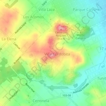
Name: Cerro Granito topographic map, elevation, terrain.
Average elevation: 235 m
Minimum elevation: 186 m
Maximum elevation: 305 m
Thank you for supporting this site ❤️
Make a donation
Make a donation
Other topographic maps
Click on a map to view its topography, its elevation and its terrain.
Los Pinos (Suboficiales del Ejército Argentino)
Argentina > Buenos Aires > Tandil
Average elevation: 188 m
Thank you for supporting this site ❤️
Make a donation
Make a donation