
Thank you for supporting this site ❤️
Make a donation
Make a donation
Crangeat topographic map
Click on the map to display elevation.
Thank you for supporting this site ❤️
Make a donation
Make a donation
About this map
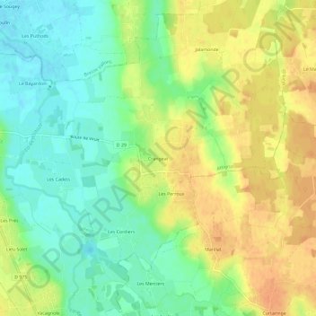
Name: Crangeat topographic map, elevation, terrain.
Average elevation: 218 m
Minimum elevation: 199 m
Maximum elevation: 236 m
Thank you for supporting this site ❤️
Make a donation
Make a donation
Other topographic maps
Click on a map to view its topography, its elevation and its terrain.
Château de Salvert
France > Auvergne-Rhône-Alpes > Ain > Attignat > Les Bodières
Average elevation: 214 m