
Thank you for supporting this site ❤️
Make a donation
Make a donation
Pelenna topographic map
Click on the map to display elevation.
Thank you for supporting this site ❤️
Make a donation
Make a donation
About this map
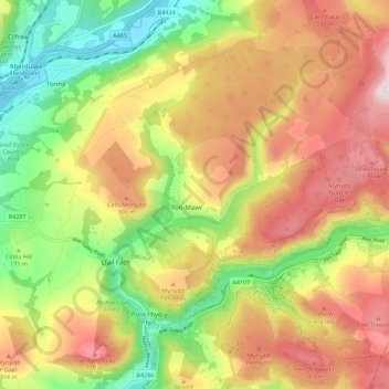
Name: Pelenna topographic map, elevation, terrain.
Location: Pelenna, Neath Port Talbot, Wales, United Kingdom (51.62782 -3.77825 51.68451 -3.66671)
Average elevation: 217 m
Minimum elevation: 4 m
Maximum elevation: 435 m
Thank you for supporting this site ❤️
Make a donation
Make a donation
Other topographic maps
Click on a map to view its topography, its elevation and its terrain.
Thank you for supporting this site ❤️
Make a donation
Make a donation
Thank you for supporting this site ❤️
Make a donation
Make a donation
Thank you for supporting this site ❤️
Make a donation
Make a donation
Thank you for supporting this site ❤️
Make a donation
Make a donation
Thank you for supporting this site ❤️
Make a donation
Make a donation
Thank you for supporting this site ❤️
Make a donation
Make a donation
Thank you for supporting this site ❤️
Make a donation
Make a donation
Thank you for supporting this site ❤️
Make a donation
Make a donation
Thank you for supporting this site ❤️
Make a donation
Make a donation
Port Talbot
United Kingdom > Wales > Neath Port Talbot
Port Talbot sea floor topography ranges from 0 to 15 metres (0 to 50 ft) within Swansea Bay. There are many patches within the bay including the North Kenfig patches, green grounds, outer green grounds, madjoe and stalheim. These patches are created from faults, hollows, general topography and other factors.…
Average elevation: 76 m
Thank you for supporting this site ❤️
Make a donation
Make a donation