
Thank you for supporting this site ❤️
Make a donation
Make a donation
Goleen topographic map
Click on the map to display elevation.
Thank you for supporting this site ❤️
Make a donation
Make a donation
About this map
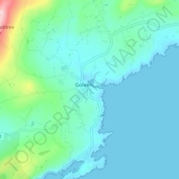
Name: Goleen topographic map, elevation, terrain.
Location: Goleen, West Cork, Comté de Cork, Munster, P81 R928, Irlande (51.47503 -9.73126 51.51503 -9.69126)
Average elevation: 52 m
Minimum elevation: -6 m
Maximum elevation: 315 m
Thank you for supporting this site ❤️
Make a donation
Make a donation
Other topographic maps
Click on a map to view its topography, its elevation and its terrain.