
Thank you for supporting this site ❤️
Make a donation
Make a donation
Pola de Somiedo topographic map
Click on the map to display elevation.
Thank you for supporting this site ❤️
Make a donation
Make a donation
About this map
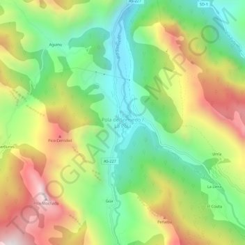
Name: Pola de Somiedo topographic map, elevation, terrain.
Location: Pola de Somiedo, Somiedo, Asturias, 33840, España (43.07315 -6.27725 43.11315 -6.23725)
Average elevation: 1,065 m
Minimum elevation: 637 m
Maximum elevation: 1,665 m
Thank you for supporting this site ❤️
Make a donation
Make a donation
Other topographic maps
Click on a map to view its topography, its elevation and its terrain.