
Thank you for supporting this site ❤️
Make a donation
Make a donation
Cimacan topographic map
Click on the map to display elevation.
Thank you for supporting this site ❤️
Make a donation
Make a donation
About this map
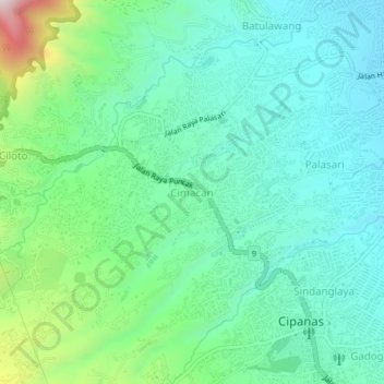
Name: Cimacan topographic map, elevation, terrain.
Location: Cimacan, Cianjur, West Java, Java, 43253, Indonesia (-6.73708 107.00879 -6.69708 107.04879)
Average elevation: 1,105 m
Minimum elevation: 939 m
Maximum elevation: 1,627 m
Thank you for supporting this site ❤️
Make a donation
Make a donation
Other topographic maps
Click on a map to view its topography, its elevation and its terrain.