
Thank you for supporting this site ❤️
Make a donation
Make a donation
Loop Head topographic map
Click on the map to display elevation.
Thank you for supporting this site ❤️
Make a donation
Make a donation
About this map
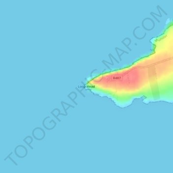
Name: Loop Head topographic map, elevation, terrain.
Average elevation: 5 m
Minimum elevation: 0 m
Maximum elevation: 72 m
Thank you for supporting this site ❤️
Make a donation
Make a donation
Other topographic maps
Click on a map to view its topography, its elevation and its terrain.
Cliffs of Moher
Die Klippen ragen an vielen Stellen nahezu senkrecht aus dem atlantischen Ozean und erstrecken sich über mehr als acht Kilometer. Am Südende, dem Hag’s Head, haben sie eine Höhe von ungefähr 120 m, nördlich des O’Brien’s Tower erreichen sie sogar 214 m.
Average elevation: 55 m
Thank you for supporting this site ❤️
Make a donation
Make a donation
Thank you for supporting this site ❤️
Make a donation
Make a donation