
Thank you for supporting this site ❤️
Make a donation
Make a donation
Link Sar topographic map
Click on the map to display elevation.
Thank you for supporting this site ❤️
Make a donation
Make a donation
About this map
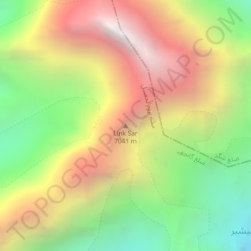
Name: Link Sar topographic map, elevation, terrain.
Location: Link Sar, Gilgit-Baltistan, Pakistan (35.44394 76.59598 35.44404 76.59608)
Average elevation: 5,885 m
Minimum elevation: 4,833 m
Maximum elevation: 6,951 m
Thank you for supporting this site ❤️
Make a donation
Make a donation
Other topographic maps
Click on a map to view its topography, its elevation and its terrain.