
Frontenac topographic map
Interactive map
Click on the map to display elevation.
About this map
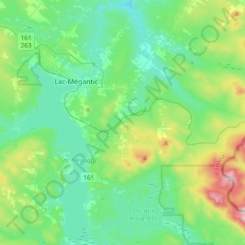
Name: Frontenac topographic map, elevation, terrain.
Location: Frontenac, Le Granit, Estrie, Québec, Canada (45.45305 -70.91071 45.63881 -70.67544)
Average elevation: 476 m
Minimum elevation: 354 m
Maximum elevation: 893 m
Other topographic maps
Click on a map to view its topography, its elevation and its terrain.
Lac aux Araignées
Lac aux Araignées, 4e Rang, Frontenac, Le Granit, Estrie, Québec, Canada
Average elevation: 434 m