
Thank you for supporting this site ❤️
Make a donation
Make a donation
Remkersleben topographic map
Click on the map to display elevation.
Thank you for supporting this site ❤️
Make a donation
Make a donation
About this map
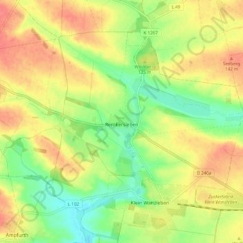
Name: Remkersleben topographic map, elevation, terrain.
Average elevation: 120 m
Minimum elevation: 91 m
Maximum elevation: 146 m
Thank you for supporting this site ❤️
Make a donation
Make a donation
Other topographic maps
Click on a map to view its topography, its elevation and its terrain.
Stadt Frankfurt
Deutschland > Sachsen-Anhalt > Börde > Wanzleben-Börde
Die kleine Siedlung in der Magdeburger Börde hat 35 Einwohner (Stand 2008) und liegt südwestlich von Wanzleben, südlich der von Oschersleben nach Wanzleben führenden Bundesstraße 246. In der Nähe befindet sich eine kleine Erhebung mit einer Höhe von 113 Metern. Nördlich von Stadt Frankfurt stehen die…
Average elevation: 104 m