
Thank you for supporting this site ❤️
Make a donation
Make a donation
Dandi topographic map
Click on the map to display elevation.
Thank you for supporting this site ❤️
Make a donation
Make a donation
About this map
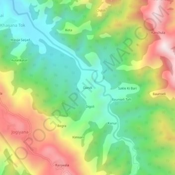
Name: Dandi topographic map, elevation, terrain.
Location: Dandi, Yamkeshwar, Pauri Garhwal, Uttarakhand, 246121, India (29.94094 78.35297 29.98094 78.39297)
Average elevation: 886 m
Minimum elevation: 551 m
Maximum elevation: 1,389 m
Thank you for supporting this site ❤️
Make a donation
Make a donation
Other topographic maps
Click on a map to view its topography, its elevation and its terrain.
Elephant Pound Rajaji National park Uttrakhand
India > Uttarakhand > Yamkeshwar
Average elevation: 455 m
Elephant Pound Rajaji National park Uttrakhand
India > Uttarakhand > Yamkeshwar
Average elevation: 455 m
Elephant Pound Rajaji National park Uttrakhand
India > Uttarakhand > Yamkeshwar
Average elevation: 455 m
Thank you for supporting this site ❤️
Make a donation
Make a donation
Elephant Pound Rajaji National park Uttrakhand
India > Uttarakhand > Yamkeshwar
Average elevation: 455 m
Elephant Pound Rajaji National park Uttrakhand
India > Uttarakhand > Yamkeshwar
Average elevation: 455 m