
Kurkhiya topographic map
Interactive map
Click on the map to display elevation.
About this map
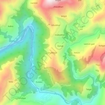
Name: Kurkhiya topographic map, elevation, terrain.
Average elevation: 1,004 m
Minimum elevation: 667 m
Maximum elevation: 1,519 m
Other topographic maps
Click on a map to view its topography, its elevation and its terrain.
gehunlad
India > Uttarakhand > Chaubatta Khal
gehunlad, Chaubatta Khal, Pauri Garhwal District, Uttarakhand, India
Average elevation: 1,625 m
Chaubattakhal
India > Uttarakhand > Chaubatta Khal
Chaubattakhal, Chaubatta Khal, Pauri Garhwal District, Uttarakhand, 246162, India
Average elevation: 1,537 m