
Thank you for supporting this site ❤️
Make a donation
Make a donation
Wildstrubel topographic map
Click on the map to display elevation.
Thank you for supporting this site ❤️
Make a donation
Make a donation
Wildstrubel
Le Wildstrubel est un sommet du massif des Alpes bernoises culminant à 3 244 m d'altitude, à cheval sur le canton de Berne et le canton du Valais, en Suisse.
Thank you for supporting this site ❤️
Make a donation
Make a donation
About this map
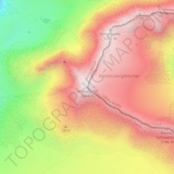
Name: Wildstrubel topographic map, elevation, terrain.
Average elevation: 2,849 m
Minimum elevation: 2,293 m
Maximum elevation: 3,239 m
Thank you for supporting this site ❤️
Make a donation
Make a donation