
Thank you for supporting this site ❤️
Make a donation
Make a donation
Artigue topographic map
Click on the map to display elevation.
Thank you for supporting this site ❤️
Make a donation
Make a donation
About this map
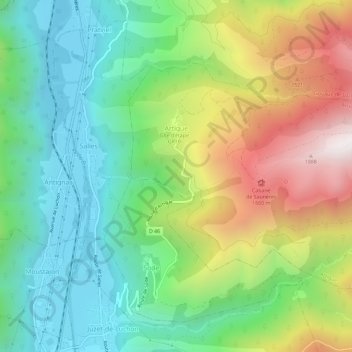
Name: Artigue topographic map, elevation, terrain.
Average elevation: 1,070 m
Minimum elevation: 589 m
Maximum elevation: 1,926 m
Thank you for supporting this site ❤️
Make a donation
Make a donation
Other topographic maps
Click on a map to view its topography, its elevation and its terrain.
Luchon-Superbagnères
Francia > Occitania > Alto Garona > Saint-Aventin > Luchon-Superbagnères
Average elevation: 1,331 m