
Thank you for supporting this site ❤️
Make a donation
Make a donation
Merlán topographic map
Click on the map to display elevation.
Thank you for supporting this site ❤️
Make a donation
Make a donation
About this map
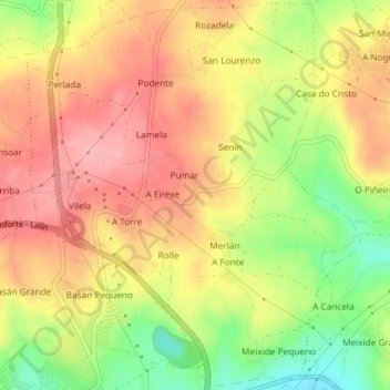
Name: Merlán topographic map, elevation, terrain.
Location: Merlán, Chantada, Lugo, Galicia, 27517, España (42.61104 -7.77212 42.63756 -7.74069)
Average elevation: 543 m
Minimum elevation: 468 m
Maximum elevation: 596 m
Thank you for supporting this site ❤️
Make a donation
Make a donation
Other topographic maps
Click on a map to view its topography, its elevation and its terrain.
Thank you for supporting this site ❤️
Make a donation
Make a donation
Thank you for supporting this site ❤️
Make a donation
Make a donation
Thank you for supporting this site ❤️
Make a donation
Make a donation
Thank you for supporting this site ❤️
Make a donation
Make a donation