
Thank you for supporting this site ❤️
Make a donation
Make a donation
Wielki Giewont topographic map
Click on the map to display elevation.
Thank you for supporting this site ❤️
Make a donation
Make a donation
About this map
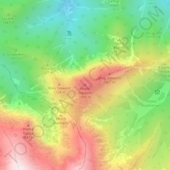
Name: Wielki Giewont topographic map, elevation, terrain.
Average elevation: 1,478 m
Minimum elevation: 1,021 m
Maximum elevation: 2,042 m
Thank you for supporting this site ❤️
Make a donation
Make a donation
Other topographic maps
Click on a map to view its topography, its elevation and its terrain.
Czarny Staw Gąsienicowy
Poland > Lesser Poland Voivodeship > Tatra County > Zakopane
Average elevation: 1,799 m