
Thank you for supporting this site ❤️
Make a donation
Make a donation
Hochwald topographic map
Click on the map to display elevation.
Thank you for supporting this site ❤️
Make a donation
Make a donation
About this map
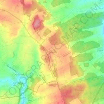
Name: Hochwald topographic map, elevation, terrain.
Average elevation: 688 m
Minimum elevation: 628 m
Maximum elevation: 743 m
Thank you for supporting this site ❤️
Make a donation
Make a donation
Other topographic maps
Click on a map to view its topography, its elevation and its terrain.
Hausen
Deutschland > Baden-Württemberg > Landkreis Rottweil > Rottweil
In Rottweil steht der 246 Meter hohe TK-Elevator-Testturm, der weltweit zweithöchste Testturm für Aufzugsanlagen. Die Konstruktion dient dem Test und der Zertifizierung von Hochgeschwindigkeitsaufzügen. Die öffentliche Besucherplattform auf 232 Meter Höhe ist die höchste Besucherplattform Deutschlands.…
Average elevation: 661 m