
Thank you for supporting this site ❤️
Make a donation
Make a donation
Schwanden topographic map
Click on the map to display elevation.
Thank you for supporting this site ❤️
Make a donation
Make a donation
About this map
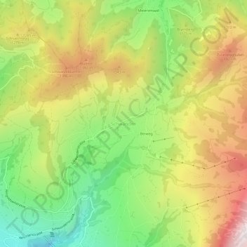
Name: Schwanden topographic map, elevation, terrain.
Average elevation: 1,142 m
Minimum elevation: 649 m
Maximum elevation: 1,703 m
Thank you for supporting this site ❤️
Make a donation
Make a donation
Other topographic maps
Click on a map to view its topography, its elevation and its terrain.
Sigriswil
Schweiz > Bern > Verwaltungskreis Thun
Ein weiteres in der Gemeinde seit Jahrhunderten fest verankertes Brauchtum ist der Zweitjänner, anlässlich dessen sich die ledigen Burschen der Gemeinde dorfweise zu Neujahrsgesellschaften zusammenschliessen. Die Neujahrsgesellschaften vertreiben mit ihren Treicheln an Silvester die bösen Geister und…
Average elevation: 959 m
Thank you for supporting this site ❤️
Make a donation
Make a donation