
Souplicourt topographic map
Interactive map
Click on the map to display elevation.
About this map
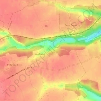
Name: Souplicourt topographic map, elevation, terrain.
Average elevation: 182 m
Minimum elevation: 133 m
Maximum elevation: 197 m
Other topographic maps
Click on a map to view its topography, its elevation and its terrain.
Mesnil Huchon
France > Hauts-de-France > Somme > Hescamps > Mesnil Huchon
Mesnil Huchon, Hescamps, Amiens, Somme, Hauts-de-France, France métropolitaine, 80290, France
Average elevation: 200 m
Agnières
France > Hauts-de-France > Somme > Hescamps
Agnières, Hescamps, Amiens, Somme, Hauts-de-France, France métropolitaine, 80290, France
Average elevation: 184 m