
Thank you for supporting this site ❤️
Make a donation
Make a donation
Wassen topographic map
Click on the map to display elevation.
Thank you for supporting this site ❤️
Make a donation
Make a donation
About this map
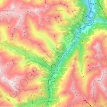
Name: Wassen topographic map, elevation, terrain.
Location: Wassen, Uri, Suisse (46.67617 8.43903 46.78056 8.63806)
Average elevation: 1,941 m
Minimum elevation: 492 m
Maximum elevation: 3,184 m
Thank you for supporting this site ❤️
Make a donation
Make a donation
Other topographic maps
Click on a map to view its topography, its elevation and its terrain.
Col de l'Oberalp
Suisse > Uri > Korporation Ursern > Andermatt
Le col de l'Oberalp (en romanche Alpsu ou Cuolm d'Ursera, en allemand Oberalppass) est situé dans les Alpes suisses, entre les Alpes glaronaises et les Alpes lépontines, à 2 044 mètres d'altitude. Il permet de relier la vallée du Rhin antérieur à Andermatt.
Average elevation: 2,219 m